Educational path through the ridge of the Greater Fatra
Contacts
Description
The Greater Fatra Mountains themselves are extremely fascinating and rich in unique natural phenomena, which can be understood even more thanks to educational trails. For alpine tourists, therefore, a big attraction is also the medium-challenging Educational Trail of the Greater Fatra.
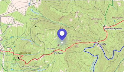
The trail passes through the protected landscape area of Greater Fatra. It has a self-service character and its focus is natural science, history and conservation. It measures 11.1 km and has 9 stops.
If you decide to explore the beauties of Fatra along this educational trail, prepare a quiet hike in about 5 hours.
At its highest point, you will overcome the elevation of 716 meters. The starting point for mapping the natural beauties of the Greater Fatra can be for you villages of Staré Hory, Turecká - Líška or Liptovské Revúce.
Along the way, the information boards will introduce you to the local flora and fauna, interesting geomorphological facts about the locality as well as to the sheep farming, which this region of Slovakia has become famous for.
Enjoy the fresh mountain air, beautiful views, gain new energy, and enjoy the good mood when you return along the path back.
You may need some: accommodation TureckáMap
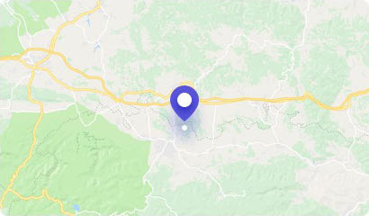
Tourist map (GPS 48.87676, 19.07878)
Google maps (Navigation)
Comments [0]
There are no comments. You can add comment or upload photos of this attraction.
Accommodation
Nearby things to do at Educational path through the ridge of the Greater Fatra
0.0 km
Krížna Hill - 1574 m asl.
Hiking
The hill Krížna is a massive mountain peak and also the second highest peak of the Greater Fatra. It is one of the main tourist destinations in the mountains.
Krížna Hil...
Turecká
2.5 km
Kráľova skala (King's Rock) - 1377 m asl
Hiking
One of the traditional lookouts of the Greater Fatra is the Kráľova skala (King's Rock). This distinctive cliff is situated near the intersection of hiking trails in the ...
Turecká
2.7 km
Majer’s Rock
Hiking
Majer's Rock is a unique natural creation. Thanks to its uniqueness and natural exceptionality, it is included in the natural monuments of Slovakia.
It is surrounded by ...
Staré Hory
2.8 km
Ostredok - 1592 m asl
Hiking
The nature of Liptov region is magical. Therefore, it is no surprise that it welcomes many tourists from entire Slovakia and abroad every year. One of the most popular pe...
Liptovské Revúce
5.8 km
Necpalské Waterfalls
Waterfalls
One of the valleys, which divide the massif of the Greater Fatra and the mouth of the Turčianska Basin, is the Necpalská Valley. It lies north of Blatnická and Gaderská V...
Necpaly
6.5 km
Harmanecká tisina
Other attractions
Enthusiasts of intact nature and tourism will certainly appeale to the national nature reserve Harmanecká tisina, which lies north of the Malý Šturec Saddle. It is part o...
Dolný Harmanec
6.9 km
To Ploská Hill with kids
Hiking
Tourism in the GreaterFatra is different than in the Tatra Mountains. There, you do not have to overcome endless meters, climb rocky sections and meet crowds of tourists....
Liptovské Revúce
7.0 km
Dekrétová Cave
Caves
In the vicinity of the well-known and popular Harmanecká Cave, there is yet another, yet not well known Dekrétová Cave. The entrance to the cave is situated in the opposi...
Dolný Harmanec