Jakubina Hill - 2194 m asl
Contacts
Description
Jakubina Hill could be peacefully named for a guardian of the Western Tatras. It is a distinctive pyramid hill, which is the second highest peak of the Western Tatras after Bystrá, but it is certainly also popular with tourists.
The ascent to Jakubina Hill is accompanied by a passage through two charming valleys - Račkova and Jamnická valleys, decorated with beautiful mountain lakes. In order to reach the top of the hill, you have to do more effort, as it is a more challenging hike and a steep climb to the main ridge.
The very top is grassy and offers beautifully vast views over a wide area. There will be deep mountain valleys in front of your eyes, huge peaks of the surrounding hills, and perhaps you will also see chamois flocks. At the top, you can relax and enjoy some refreshments.
It is possible to climb Jakubina along the marked hiking trail from Račkova Valley (approx. 6 km away). In winter, the trails of this route are closed.
You may need some: accommodation PribylinaMap
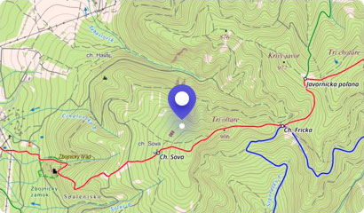
Tourist map (GPS 49.19159, 19.80069)
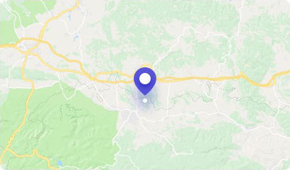
Google maps (Navigation)
Comments [0]
There are no comments. You can add comment or upload photos of this attraction.
Accommodation
Nearby things to do at Jakubina Hill - 2194 m asl
0.7 km
Račkova Valley
Hiking
Račkova Valley is a well-known locality of the Western Tatras for tourists, and therefore it is also frequently visited in every season. It has a length of more than 5 ki...
Pribylina
1.6 km
Račkovo Saddle - 1958 m asl
Hiking
Račkovo Saddle is another of a series of large and grassy mountain saddles in the main ridge of the Western Tatras. It is situated on the Slovak - Polish border near the ...
Pribylina
1.7 km
Klin Hill - 2173 m asl
Hiking
The massive, rocky hill of Klin with its typical pyramid shape is the type of hill you see from a distance. Its pointed peak and wide slopes will encourage you to make an...
Pribylina
2.7 km
Jamnické mountain lakes
Hiking
Very nice and frequently visited mountain lakes of western part of Tatras include Jamnické lakes. They are located in the beautiful surroundings of the highest part of th...
Žiar
3.1 km
Bystrá - 2248 m asl
Hiking
Bystrá Hill is due to its beauty, diversity, but also the altitude considered the Queen of West Tatras. This spectacular two-thousander rises above the Račková, Bystrá an...
Liptovská Kokava
3.3 km
Volovec - 2063 m asl
Hiking
Volovec Hill is a charming two thousander, which will not leave any tourists cool. Its vast slopes copy the Slovak - Polish border and for many, it is a popular stopover ...
Žiar
3.8 km
Plačlivé - 2125 m asl
Hiking
Between the hills of Baníkov and the Ostrý Roháč, there is the hill of Plačlivé, often called "Plačlivô". It is a less known hill belonging to the central ridge of the We...
Žiar
4.1 km
Pyšné sedlo - 1791 m asl
Hiking
In the Western Tatras, where the Slovak-Polish border meets, lies the sprawling Pyšné sedlo (Proud Saddle). This alpine saddle is characterized by the fact that it is one...
Pribylina - Podbanské