Stolica - 1476 m asl
Contacts
Description
Stolica Hill is the highest hill in the Stolické Mountains. It is characterized by gradually rising, wide and massive mountain ridges, covered by vast meadows, which gradually pass into spruce forests.
The ascent to Stolica is especially enchanting during inversion, when you walk up the mountain meadows high above the clouds. Nature is almost untouched by human activity. From the top of Stolica, there are beautiful views that are crowded with spruce trees. At the same time, the blue and green tourist signs pass through. The ascent route to the Stolica Hill is characterized mainly by its long, gradual ascent. Only the last meters are steeper. The most ideal starting point is the village of Rejdová (about 11 km). Other alternatives are Čierna Lehota or Muránska Zdychava.
You may need some: accommodation district RožňavaMap
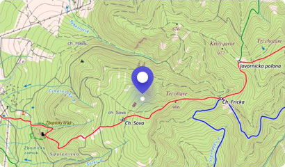
Tourist map (GPS 48.77368, 20.20662)
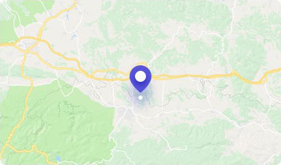
Google maps (Navigation)
Comments [0]
There are no comments. You can add comment or upload photos of this attraction.
Accommodation
Nearby things to do at Stolica - 1476 m asl
5.1 km
Kohút Hill - 1409 m asl
Hiking
The surroundings of the town of Revúca are formed by several hills that attract tourists. However, the most prominent of them is definitely the Kohút Hill, which is also ...
Muránska Zdychava
7.0 km
Predná Hora Mansion
Castles, chateaus, mansions
Muránska Plain offers not only excellent tourism, but also great opportunities to follow the footsteps of ancient times and discover a piece of Slovak history.
Visit the...
Muránska Huta
7.4 km
Recreational area of Predná Hora
Lakes and pools
Predná Hora is situated in a natural environment surrounded on the border of the National Park Muránska Plain. Predná Hora recreation area offers comprehensive services i...
Muráň
8.5 km
SKI Telgárt
Skiing
Telgárt Ski Center is located near the village of Telgárt in the Upper Pohronie region, in the valley between the Low Tatras, the Slovak Paradise and the Slovak Ore Mount...
Telgárt
9.1 km
Slavošovský and Koprášsky Tunnel
Technical monuments
The construction of an alternative line to Slavošovce was started in 1941. The reason was the affiliation of the southern Slovak territories to Hungary after the Vienna A...
Slavošovce
9.1 km
Chmaroš Viaduct
Technical monuments
The characteristic feature of the village of Telgárt is not only a charming alpine nature, but also a unique object called the Chmaroš Viaduct. It is a stone railway brid...
Telgárt
9.5 km
Spring of Hron
Other attractions
The River Hron is the second longest Slovak river, and therefore deserves due attention. Hron measures 298 kilometers, flows only through Slovakia and flows into the Danu...
Telgárt
9.7 km
Radzim - 991 m asl
Hiking
The dominant feature of the upper Gemer region is the limestone massif of Radzim belonging to Stolické Hills. The Radzim massif is not very popular with tourists and is m...
Brdárka