
Description
The time required is approx. 30 minutes.
The time required is approx. 30 minutes.
Tajch artificial water reservoir is located in the part of Nová Baňa called Stále. The reservoir is part of a larger recreational complex. It was built in 1792 - 1794 as part of the former mining water system.
The Tajch reservoir is surrounded by beautiful nature and divine silence. It is sought after not only by holidaymakers, but also by fishermen. The water in the reservoir is refreshing and clear. It is enriched with grassy banks that serve for sunbathing and relaxation.
For active movement of vacationers, there is a volleyball court, badminton court, tennis courts and a beach volleyball court. The area is a good starting point for trips to the surrounding countryside along marked and unmarked hiking and biking trails.
The recreational area also includes a guest house that offers accommodation, a restaurant, a seasonal outdoor pool and a bar. During the summer, Tajch is a popular venue for concerts, cinemas in the amphitheater, motoring rides and various sporting events.
You may need some: accommodation Nová BaňaMap
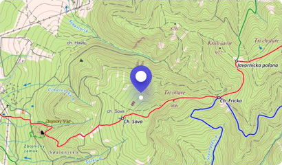
Tourist map (GPS 48.45575, 18.63639)
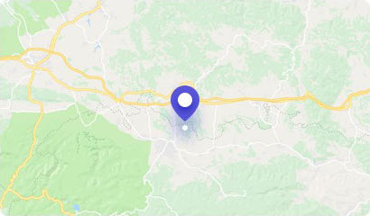
Google maps (Navigation)
Comments [5]

Anonym • Apr 2024
„Aká je najväčšia hĺbka vody v Tajchu, vedel by niekto ?“
Zita Antalíková • Jun 2023
„Okolie super len treba trochu upravit vodnú plochu aj vstup “
Zita Antalíková • Jun 2023
Photos added:
Anonym • Aug 2022
„V Novej Bani som bola dva krat v zivote a moje nadsenie od prvej chvile je na urovni 200bodov. Priroda,mestecko,ludia,prostredie,atmosfera;pokoj a klud-cisty raj a oddych na Tajchu je stopercentna zaruka. Hodnotim najpozitivnejsie. Klobuk dole
“
Anonym • Jul 2022
„Boli sme tu, je to fajn voda aj prostredie :) clovek si dobre zaplava a je tam aj priestor na deku pri jazere.. za nas fajn len ta pristupove cesta je hrozne uzka..“
Accommodation
Nearby things to do at Tajch Nová Baňa
2.9 km
Educational path Zvonička
Hiking
Educational trail Zvonička leads from Nová Baňa to the bell tower from the 19th century, which was built as a part of the pilgrimage site Kohútovo. The bell tower was lat...
Nová Baňa
3.1 km
Sedlová skala (Saddle Rock) - 778 m asl
Hiking
Perhaps the most beautiful sightseeing spot in the Pohronský Inovec mountain range is the Sedlová skala (Saddle Rock). This massive mountain of volcanic origin rises abov...
Nová Baňa
3.6 km
Bujakov Hill
Hiking
Bujakov Hill Nature Reserve is located on the border of villages of Veľká Lehota and Nová Baňa. It is a site that is a place of extraordinary occurrence of rare and pro...
Nová Baňa
3.6 km
Hron Region Museum - Town Hall of Nová Baňa
Museums and history
The architectural landmark of the center of Nová Baňa is undoubtedly the building of the former town hall, which is the seat of the Hron Region Museum. The collection of ...
Nová Baňa
3.9 km
Červená skala (Red Rock) - 458 m asl
Hiking
Surroundings of Nová Baňa offers beautiful excursions to spend the afternoon or weekend in the local forests. The surrounding hills and peaks offer not only excellent hik...
Nová Baňa
4.1 km
Vojšín - 819 m asl
Hiking
Vojšín is the third highest peak of the Pohronský Inovec mountain range. It is located near the former free royal and mining town - Nová Baňa. Vojšín Hill is the result o...
Malá Lehota
5.2 km
Nature trail of Vojšín
Hiking
The Nature trail of Vojšín is built between Stará Huta in Nová Baňa and Malá Lehota. On a 12.5 km route you will be guided through the most attractive sections of this pa...
Nová Baňa - Stará Huta
5.3 km
Equestrial Center of St. Francis
Horses, riding
Riding without contact with civilization, immediate contact with horse, changing scenery of nature and clean air. This will allow you to relax from everyday worries and e...
Horné Hámre