Description
The largest mountain complex of the Slovak Ore Mountains is the Volovské Hills, which are very popular among tourists. Their part near the town of Rožňava consists of about 10 meters high group of limestone on the rocky peak of Volovec hill called Skalisko.
Interestingly, about 700 meters to the northwest, there is another hill of Volovec (1 284 m above sea level) together forming a double peak Skalisko - Volovec, while another peak Volovec (1213 m above sea level) is located 800 meters northwest of the Volovec Saddle (1155 n.m.)
The whole area of the hill is covered with scrub and rich flora. While climbing you will overcome almost a thousand altitude meters, but the route is pleasant and leads through a well-groomed forest path. Before the final steep ascent, you can rest in a cottage Volovec, which offers catering for tourists and even accommodation. At the cottage, you will find a hearty mountain spring, which is particularly suitable in summer.
The top part consists of, as expected, rocks, but also a larger meadow. From here, you can enjoy beautiful circular views in good weather. Under ideal conditions, in addition to the High and Low Tatras, you can see as far as to Ukraine and Hungary.
During World War II, Skalisko was Hungary's highest peak. They called it Baračka, derived from the Hungarian Barátkö, which means Friendly Stone. There is an international long-distance hiking trail E8, which is the longest hiking trail in Slovakia called the Trail of the Slovak National Uprising Heroes.
There are several marked hiking trails to reach Skalisko. Excellent starting points are especially the villages of Betliar (about 9km), Čučma (about 9km), Henclová, but also Súľová Saddle or Uhornianske Saddle.
You may need some: accommodation district RožňavaMap
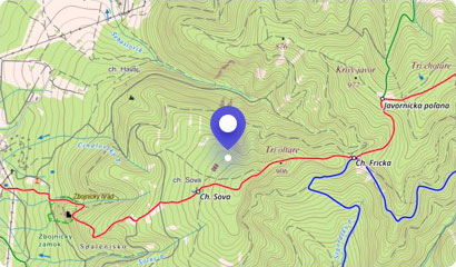
Tourist map (GPS 48.74409, 20.57532)
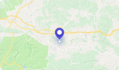
Google maps (Navigation)
Comments [0]
There are no comments. You can add comment or upload photos of this attraction.
Accommodation
Nearby things to do at Volovec - Skalisko - 1293 m asl
6.4 km
Zlatý stôl (Golden table) - 1322 m asl
Hiking
The highest peak of the Volovské vrchy Mountains, the Zlatý stôl (Golden table), rises above the picturesque villages of Stará Voda, Henclová, Úhorná and Smolník. Its mys...
Švedlár
6.4 km
Betliar Mansion
Castles, chateaus, mansions
Seven kilometers from the mining town of Rožňava, there is the picturesque village of Betliar, which boasts of a magnificent manor house with original furnishings and col...
Betliar
6.7 km
Hekerova Hill - 1260 m asl
Hiking
The southwestern part of the Volovské Hills is rich in several distinctive and very attractive hills. One of them is Hekerová Hill, which rises above the village of Uhorn...
Smolník
9.5 km
Gallery of the Mining Museum
Museums and history
On the Mining Squar, in the historical building of the burgher house from the 15th century, there is the Gallery of the Mining Museum.
There are regularly held short-ter...
Rožňava
9.5 km
Gallery of Mining Museum
Museums and history
The gallery is housed in a burgher's house in the center of Rožňava, whose origins go back to the end of the 15th century. This house is part of a terraced building on a ...
Rožňava
9.6 km
Úhorná Water Reservoir
Lakes and pools
The beautiful water reservoir Úhorná, also called Uhornianske Lake, is located in the arms of the Volovské Hills. It was built in the 18th century on the Smolník Brook an...
Smolník
9.6 km
Late-Renaissance Watchtower
Museums and history
An inseparable dominant of the historical center of Rožňava is the late Renaissance watchtower. It was built during the Turkish threat in 1643-1654 on the site of the ori...
Rožňava
9.7 km
Krásna Hôrka Castle - in reconstruction
Castles, chateaus, mansions
Krásna Hôrka Castle is closed since March 10, 2012 due to reconstruction works.
The picturesque Gemer area in the very heart of Slovakia boasts of an unprecedented cultu...
Krásnohorské Podhradie