Description
Hrádok pod Vtáčnikom is a sought-after climbing area. Located near the village of Kamenec pod Vtáčnikom and village of Bystričany. The location is rich in many unlocked but also secured roads and adrenaline experiences.
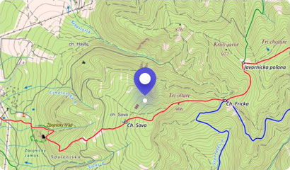
The rock massif is situated above the educational path leading from the border of the Ponitrie Protected Area above the village towards the Vtáčnik Hill. It is located in the southeastern part of Horný Hrádok. This impressive rocky area is formed by an impressive up to 100 m high andesite wall.
Hrádok is the second largest climbing area in Slovakia after the Tatras. However, except for rock climbers, Hrádok is certainly interesting for the more courageous tourists too. A secured path with ladders and chains leads to the top of the rock massif.
The adrenaline ascension brings you blood in your veins, and the breathtaking view from the summit, where the pagan fort spread out in the early days, will warm your heart. The whole Bystričianska Valley will be lie open just in front of you.
Hrádok is accessible from the village of Kamenec pod Vtáčnikom along marked hiking trail to the mouth of the Gepňár Valley and from there along unmarked paths (about 2 km) to the rocks. After climbing the Hrádok, you can connect to the hiking trail leading up to the Vtáčnik Hill.
You may need some: accommodation district PrievidzaMap
Tourist map (GPS 48.63846, 18.58222)
Google maps (Navigation)
Comments [0]
There are no comments. You can add comment or upload photos of this attraction.
Accommodation
Nearby things to do at Hrádok pod Vtáčnikom
3.4 km
Buchlov - 1041 m asl
Hiking
The Vtáčnik mountain range offers truly varied tourism. There are several nature reserves that will enchant you. One of them is Buchlov with the same name of the peak, wh...
Čereňany
4.2 km
Vtáčnik Hill - 1346 asl
Hiking
The Vtáčnik volcanic mountains with the peak of the same name is an extraordinarily nice place, which surprisingly was not hit by the crowds of tourists and lovers of var...
Bystričany
4.4 km
Žarnov - 840 m asl
Hiking
Žarnov Hill is located in the attractive volcanic mountain of Vtáčnik. Like many hills in this mountain range, Žarnov is made up of rocks and various rock formations. It ...
Oslany
5.6 km
Pokutsky Waterfall
Waterfalls
Pokutský waterfall is located in the Protected Landscape Area of Ponitrie. Pokutsky waterfall or also Waterfall on Pokutsky creek is the only known and distinctive in the...
Kľak
6.4 km
Jarabá Rock - 1169 m asl
Hiking
The spectacular volcanic mountain range of Vtáčnik offers a varied tangle of hiking trails that will take you to the most amazing forest coves, observation points and roc...
Podhradie
6.7 km
Ostrovica - 855 m asl
Hiking
The small village of Kľak is surrounded by a powerful Vtáčnik mountain range. This mountain offers not only excellent hiking in any season, but also wonderful and majesti...
Kľak
6.7 km
Ruins of Sivý Kameň Castle
Castle ruins
On the andesite hummock towering above the village of Podhradie, there are ruins of a medieval castle called Sivý Kameň (ie Grey Rock). The castle was built in the first ...
Podhradie
7.3 km
Orlí kameň (Eagle Stone) - 1126 m asl
Hiking
The mountain range of volcanic origin, Vtáčnik, is rich in many popular tourist sites. However, it also has plenty of corners, which are not so much explored by tourists,...
Podhradie