


If you always wanted to know the history of coal mining in the town of Handlová, now is the time. The educational mining trail tells you everything about the attractions of this mining town, which you have not known yet.
The educational trail was created at the initiative of the Handlová Mining Association and is intended for the general public. On 13 information boards located in the very bosom of nature you will get acquainted with the activities connected with coal mining in Handlová, as well as with the fauna and flora of the surrounding area.
For a better experience, old photos, which are placed on individual information boards, also bring the atmosphere. The route is 9.5 km long and takes about 5 hours.
You can relax and gain strength in two relaxation zones - Three Wells and One Well. Children in these relaxation areas can have fun on the merry-go-round and adults can roast for change.
The walkway is available all year round along the green hiking trail. The trail goes up in the first meters, but then just a quiet walk along the plain awaits you there.
You may need some: accommodation Handlová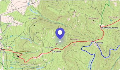
THE SWIMMING POOL IS CURRENTLY CLOSED DUE TO LONG-TERM RECONSTRUCTION!
A year-round open swimming pool in the town of Handlová is located in its marginal part. The indoo...
The landscape scenery of the town of Handlová is dominated by the distinctive, partly rocky peak of Malý Grič, which is part of the Vtáčnik mountain range. As well as oth...
Veľký Grič is an inherent landscape dominant near the town of Handlová. This volcanic hill belongs to the popular mountain range of Vtáčnik. The impressive Veľký Gríč is ...
Sometimes even smaller hikes can impress with their charm and discretion. Evidence of this is the Hájska Rock, which rises above the village of Ráztočno in the Žiar Mount...
An interesting geological phenomenon, Brusno Sand Balls, can be found in a quarry near the village of Chrenovec-Brusno near Prievidza.
These are mostly spherical but als...
The recreation centre of Remata is bounded by the low but very popular mountain of Bralova Rock. As its name suggests, the dominant feature of this hill are massive rocks...
The impressive peak called Biely kameň (White Stone) is located in the northeastern part of the volcanic mountain range Vtáčnik. It is a location where no tourist marked ...
Ski resort of Cigeľ Priedavky-Šabľová lies above the village of Cigeľ, about 7 km south of Prievidza.
The groomed slope in the resort is served by one ski lift and you w...